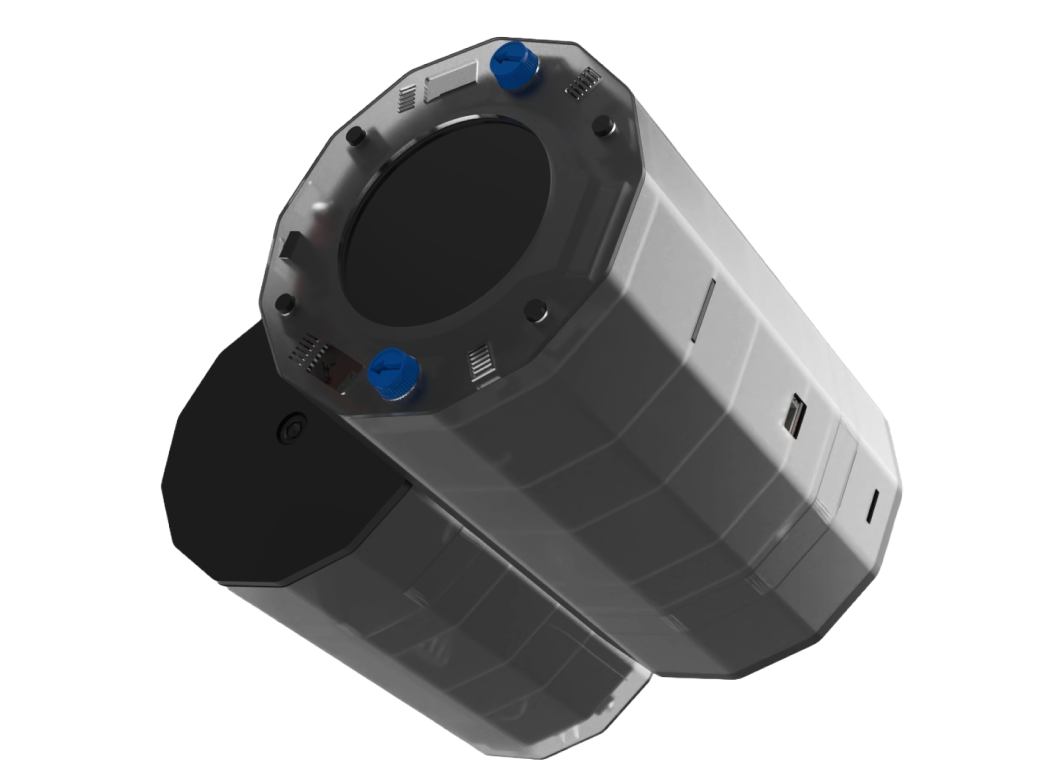
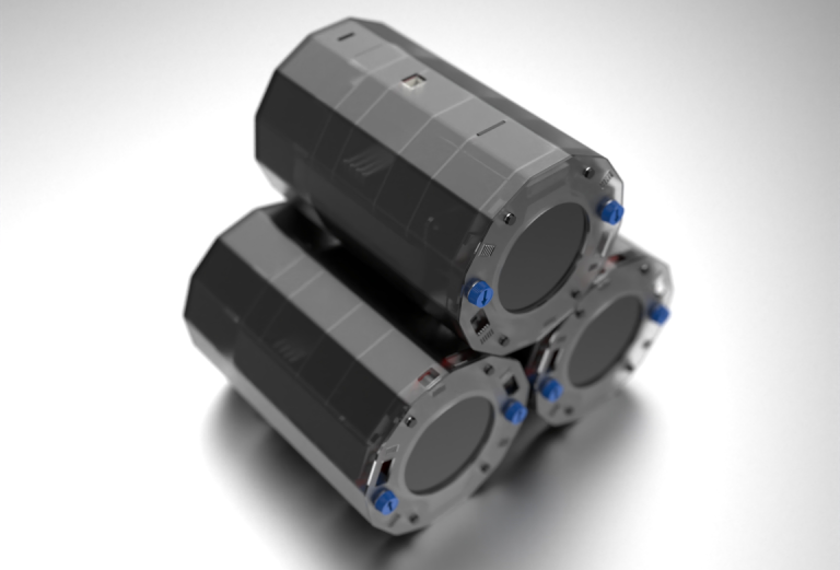
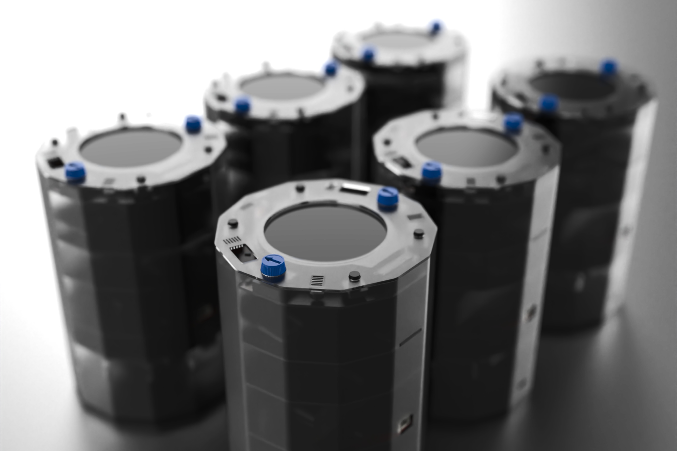
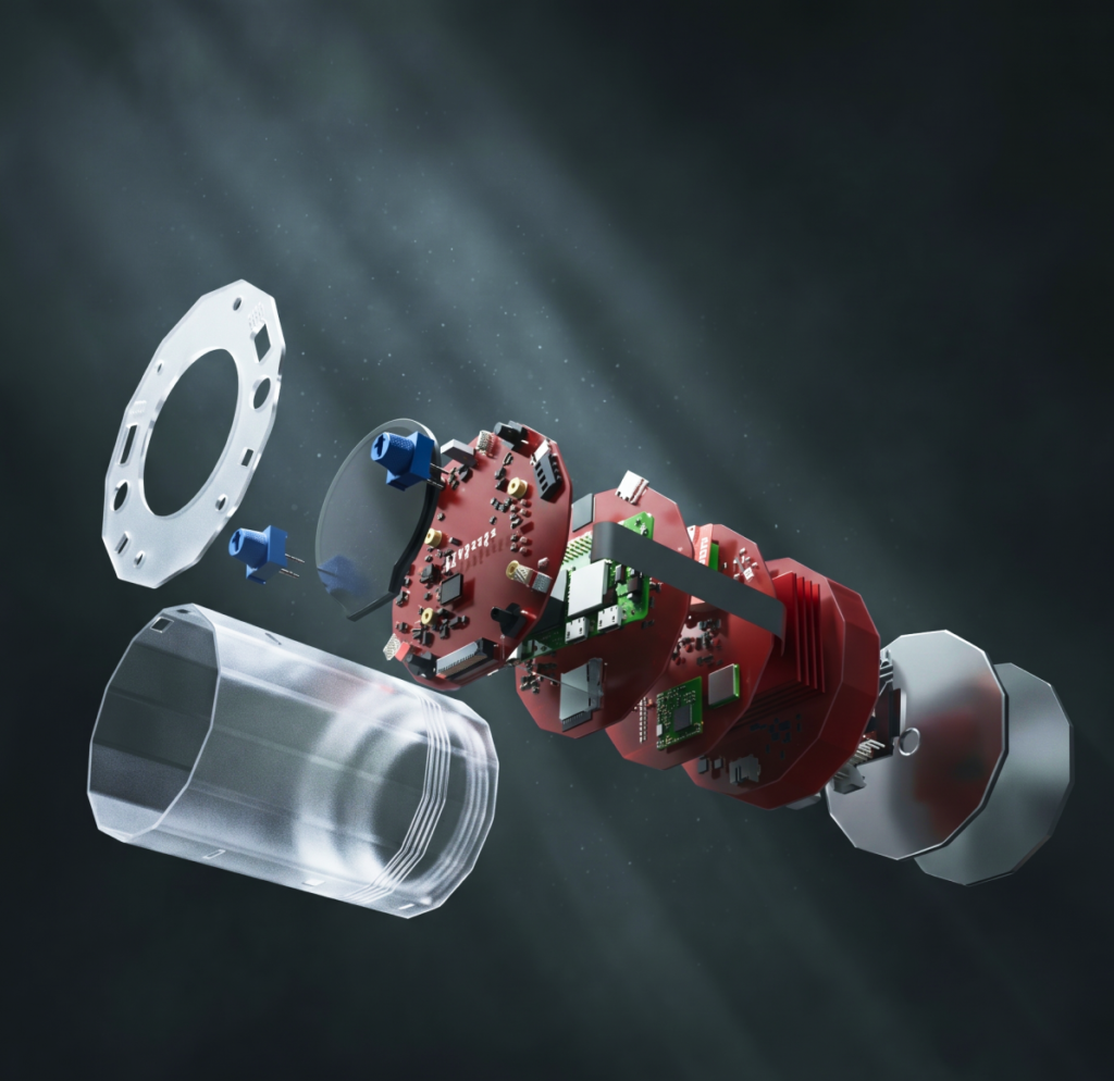
Product Launch Coming Soon · Early Access Pre Orders Opens Shortly
Pre-Order

Designed for Discovery, Built for Innovation

From environmental monitoring and wireless communication to edge computing and real-time analytics, CanSAT EDGE enables users to design, test, and deploy data-driven solutions across a wide range of scientific and engineering applications.

CanSAT  EDGE

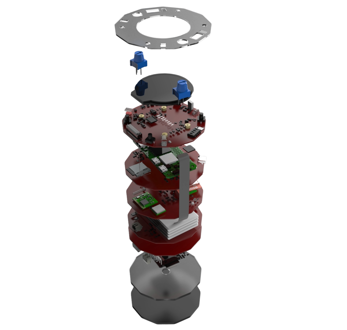
CanSAT EDGE is a compact embedded systems platform that integrates environmental sensing, motion tracking, wireless communication, edge computing, and onboard data management into a unified architecture. Built around ESP32 and Raspberry Pi Zero processing capabilities, it enables real-time data acquisition, analysis, visualization, and transmission for advanced monitoring, research, and technology development applications.

Engineered for intelligent data collection, processing, and communication.

  • ESP32 Control Processing + Raspberry Pi Edge Computing

  • 20+ Integrated Environmental & Motion Sensors

  • Multi-Network Connectivity (LoRa, GSM, Wi-Fi, Bluetooth)

  • Modular Payload Expansion with Servo & Motor Control

CanSAT EDGE Full Set
Rs. 6499
Dual-Processor Edge Computing Architecture

ESP32 and Raspberry Pi Zero processors work together to enable real-time control, sensor fusion, wireless communications, and advanced onboard data processing.

Multi-Domain Environmental Sensing Suite

Integrated pressure, temperature, humidity, UV, light, VOC, and air quality sensors provide comprehensive atmospheric and environmental characterization.

9-Axis Inertial Navigation System

Accelerometer, gyroscope, and magnetometer subsystems deliver precise motion tracking, orientation estimation, vibration analysis, and flight dynamics monitoring.

Multi-Protocol Telemetry & Communications

LoRa, GSM, Wi-Fi, and Bluetooth connectivity support long-range telemetry, remote monitoring, command uplink, and distributed data exchange.

GNSS Positioning & Mission Tracking
Integrated GPS subsystem provides geolocation, velocity estimation, route tracking, and synchronized mission timestamping for operational awareness.
Modular Payload & Expansion Interface
Dedicated payload connectors, exposed I/O channels, servo control, motor drivers, and MicroSD storage enable rapid integration of custom mission hardware.   

The Unique Capabilities & Advantages of CanSAT EDGE

Human-Machine Interaction Layer

Physical controls, DIP-switch configuration, OLED/LCD visualization, RGB indicators, buzzer alerts, and haptic feedback provide intuitive system interaction and diagnostics.

Unified Data Acquisition Framework

All sensing, positioning, communication, and logging subsystems operate within a synchronized architecture, enabling consistent timestamping and streamlined data correlation across multiple sensor domains.

Multi-Network Communication Resilience

The platform combines LoRa, GSM, Wi-Fi, and Bluetooth technologies, allowing deployment flexibility across local, remote, and infrastructure-limited environments.

Extended Operational Endurance

A 5000mAh LiPo power system, integrated charging circuitry, and solar input support prolonged field operation and autonomous deployment scenarios.

Real-Time Situational Awareness

Live sensor feedback, onboard display visualization, GPS tracking, and mobile application integration provide immediate operational insight during deployment.

Mission-Critical Data Integrity

Local MicroSD storage ensures continuous recording of telemetry, environmental measurements, and operational events even when communication links are unavailable.

Scalable Payload Development Ecosystem

Quick-connect payload interfaces and exposed I/O channels allow rapid integration, testing, and validation of custom hardware modules and experimental payloads.

Deployment-Ready Modular Architecture

A compact integrated design consolidates sensing, computing, communications, power management, and expansion capabilities into a single field-ready platform.

Edge Computing for Real-Time Intelligence

CanSAT brings advanced edge computing capabilities into a compact, mission-ready platform by combining ESP32 real-time control with Raspberry Pi Zero processing power. This dual-processor architecture enables data to be captured, analyzed, and acted upon directly at the source, minimizing reliance on external systems and cloud connectivity.

From sensor fusion and telemetry management to image processing and intelligent analytics, CanSAT transforms raw data into meaningful insights in real time. The result is faster decision-making, improved operational efficiency, and greater autonomy, empowering users to develop smarter applications, conduct advanced experiments, and unlock new possibilities across research, monitoring, and connected technology deployments.

0

Integrated Processors

ESP32 real-time control and Raspberry Pi Zero edge computing working in a unified architecture.

0 +

Concurrent Data Streams

Simultaneous processing of sensor, positioning, communication, and payload data.

GNSS-Synchronized Positioning & Navigation

CanSAT integrates a high-precision GNSS positioning subsystem that provides continuous location, velocity, and time-reference data for mission operations. By synchronizing geospatial coordinates with environmental, motion, and telemetry datasets, the platform enables accurate route reconstruction, asset tracking, trajectory analysis, and location-aware sensing. This GNSS framework transforms raw measurements into contextualized intelligence, ensuring every data point is linked to where and when it was collected.

UTC - Synchronized Time Reference
Real-time geolocation, velocity tracking, and route awareness
Geotagged Mission Data
Location-aware telemetry for tracking, mapping, and analysis

Real-Time Data Visualization & System Monitoring

CanSAT features a 2-inch round LCD display that provides immediate access to mission-critical information directly on the platform. Sensor readings, system status, positioning data, communication indicators, and operational parameters can be visualized in real time, reducing dependence on external devices during deployment.

The display acts as a local mission interface, enabling rapid diagnostics, configuration verification, and live performance monitoring. Whether deployed in field experiments, environmental monitoring applications, or autonomous systems, the integrated display enhances situational awareness and operational efficiency.

Kilometer-Scale Range
0 Inch +
Data Parameters
0 +

product gallerySome views of the product

exploded technical drawingsAdvanced hardware packet on a pocket size device

Product Technical Specifications

Processing & Computing
  • ESP32 microcontroller with integrated Wi-Fi & Bluetooth
  • Raspberry Pi Zero for edge computing applications
  • Dual-processor architecture
  • USB Type-C power and programming
  • Real-time onboard data processing
  • Edge analytics and intelligent workloads
Power Management
  • 2S 5000mAh LiPo battery
  • USB LiPo charging system
  • Solar power input support
  • Integrated power management circuitry
  • Extended deployment operation
Environmental Sensing
  • Ambient pressure sensor
  • Temperature sensor
  • Humidity sensor
  • Light intensity sensor
  • UV radiation sensor
  • VOC air-quality sensor
Motion & Orientation
  • 3-axis accelerometer
  • 3-axis gyroscope
  • 3-axis magnetometer
  • 9-DOF motion sensing
  • Vibration and movement monitoring
Navigation & Positioning
  • Integrated GNSS/GPS receiver
  • Real-time location tracking
  • Velocity and route monitoring
  • UTC-synchronized timestamps
  • Geotagged sensor datasets
Wireless Communications
  • LoRa wireless transceiver
  • LoRa ground station compatibility
  • Wi-Fi connectivity
  • Bluetooth connectivity
  • GSM cellular communication module
  • Long-range telemetry support
Display & User Interface
  • 2-inch round LCD display
  • RGB signaling LEDs
  • Status indicator LEDs
  • Control buttons
  • Adjustable control knob
  • DIP switch configuration interface
Data Logging & Storage
  • MicroSD card storage
  • Onboard telemetry recording
  • Sensor data logging
  • Mission event recording
  • Persistent local storage
Payload & Expansion
  • Quick-connect payload interface
  • Exposed I/O communication pins
  • Custom sensor integration
  • Modular hardware expansion
  • External device connectivity
Imaging & Monitoring
  • Integrated camera module
  • Image and video capture
  • Visual mission monitoring
  • Remote observation capabilities
  • Computer vision development ready
Actuation & Feedback
  • Servo driver subsystem
  • Motor driver subsystem
  • Magnetic signaling buzzer
  • Vibration feedback motor
  • Interactive alert and notification system
Software & Mobile Interface
  • Dedicated mobile application support
  • Real-time monitoring dashboard
  • Telemetry visualization tools
  • Remote system management
  • Live mission status tracking

how it worksFrom Programming to Deployment with CanSAT EDGE

CanSAT EDGE streamlines the complete data acquisition lifecycle—from system setup and sensor calibration to autonomous operation, telemetry transmission, and actionable insight generation. Combining advanced sensing, edge computing, positioning, and wireless communications, the platform transforms raw measurements into real-time intelligence for research, monitoring, and technology development.

01
Configure & Program

Configure the platform through USB Type-C or wireless interfaces. Users can customize sensor parameters, communication settings, payload behavior, logging intervals, and processing workflows. The ESP32 manages real-time control while Raspberry Pi Zero enables advanced edge computing applications.

02
Sense & Process

Once deployed, CanSAT EDGE continuously acquires environmental, motion, positioning, and system health data. Integrated edge computing capabilities process information locally, enabling sensor fusion, event detection, intelligent filtering, and real-time analytics directly onboard.

03
Transmit & Log

Critical telemetry is transmitted through LoRa, GSM, Wi-Fi, or Bluetooth communication channels while complete datasets are simultaneously stored on MicroSD storage. This dual-layer approach ensures reliable monitoring even in remote or connectivity-limited environments.

04
Visualize & Analyze

Monitor live mission performance through onboard displays, mobile applications, or ground station interfaces. GPS-referenced datasets, synchronized timestamps, and comprehensive sensor records provide a rich foundation for analysis, reporting, and decision-making.

applicationsDeployment Scenarios

Autonomous Sensing Networks

Deploy distributed sensor nodes that collect, process, and transmit data using LoRa, GSM, and Wi-Fi communication technologies.

GNSS Tracking & Asset Monitoring

Enable real-time location awareness, route tracking, geotagged data collection, and movement analysis for mobile platforms and field operations.

Remote Infrastructure Monitoring

Monitor environmental conditions, equipment status, and operational parameters in off-grid or hard-to-access locations.

What’s inside the box:

1. CanSAT EDGE
2. Modular Casing
3. Battery
4. Programming Cable
5. Expansion Cable
6. Manual

CanSAT EDGE

faqEverything You Need to Know About CanSAT

CanSAT EDGE is an integrated sensing, communication, and edge computing platform that combines environmental monitoring, GNSS positioning, wireless telemetry, onboard analytics, and data logging into a compact, deployable system.

The platform integrates pressure, temperature, humidity, UV, light intensity, VOC air-quality, accelerometer, gyroscope, magnetometer, GPS, audio, and imaging capabilities for comprehensive data acquisition.

CanSAT combines an ESP32 microcontroller with a Raspberry Pi Zero processor. The ESP32 manages real-time control and communications, while the Raspberry Pi Zero handles advanced processing, analytics, and edge computing workloads.

CanSAT EDGE is configured and programmed via USB-C or wireless interfaces, allowing users to define sensor behavior, communication modes, power profiles, and edge processing logic.

CanSAT EDGE supports Sub-GHz LoRa for long-range telemetry, Wi-Fi and Bluetooth for local connectivity, GPS for positioning, and optional cellular communication.

Yes. Integrated MicroSD storage enables continuous local recording of telemetry, sensor measurements, images, and mission data, even when communication links are unavailable.

Yes. The integrated GNSS/GPS subsystem provides real-time location tracking, route reconstruction, geotagged datasets, and UTC-synchronized timestamps for accurate spatial analysis.

Built to Sense. Designed to Analyze. Ready to Deploy.